
| Welcome | Database | Indexes | Copyright/Disclaimer | Login |
Heathcote
The first inhabitants of Heathcote were the
Dharawal people. Many places both in Heathcote and the Royal National Parks are
evidence of their occupation.
After European settlement in 1788 the town of
Sydney needed to expand by the early 1800’s and
Governor Macquarie decided to survey the whole colony of
New South Wales.
This was done by 1828 and NSW was divided into
nineteen counties with the rugged southern section being named the County of
Cumberland. The area south of the Georges River was not completed until 1835 by
the new Surveyor General Major Thomas Mitchell & he named one of four parishes
with it Heathcote. It is said he named it after one of two Heathcote brothers he
served with under the Duke of Wellington in the Portuguese Peninsular War.
During the 1830’s the main road south to
Wollongong (then named Five Islands) was via Liverpool & Appin. Mitchell
conceived the idea of a direct road with a ‘ferry’/punt crossing over the
Georges River at Lugarno and a hand punt crossing the Woronora River to the
present Woronora Road beside Boys’ Town to Bottle Forest. The New Illawarra Road
work was begun by a party of convicts and took ten years to complete.
Prior to 1843 Surveyor Drake was instructed to
survey the rich Bottle Forest/Heathcote area and marked out 14 allotments which
were granted to various holders from 1845. Mitchell’s new road divided the
settlement into east & west.
The owners were Mr Wm A B Greaves, Mr Patrick
Hynes (part portioned to Mr John Willis but forfeited), Phillip Caffray, Edward
Michael Hill, John Annan, William Fleming, Hugh Patrick (after Mr Henry Calvert
forfeited), John Erving/Irving and George Coulson.
“It is likely the settlement of Bottle Forest mainly
occupied the ridge in the vicinity of Parklands Ave in its early days” - ‘From
Bottle Forest to Heathcote’ p27 by Patrick Kennedy.
Due to isolation, poor roads and the wrecking of
the Georges River punt the settlement was abandoned by the mid 1860’s.
The Illawarra railway line had reached
Sutherland from Hurstville in 1885 and the section to Waterfall - including a
spur line into Royal National Park (which was established 1879) and known as
Loftus Junction - was completed in March 1886. The intermediate station was
Heathcote.
The Village of Heathcote (82 acres) was
proclaimed in 1886. Heathcote School opened in November 1886 mainly to cater for
the children of the men building the railway line. In March 1890 the Station
Master also acted as the post master.
There were 30 families living permanently in the
Heathcote area.

The first
brickyard in the area was established by Howe & Smith in 1879. About 1883, Isaac
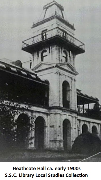
Harber, a Sydney brick master, acquired 50 acres to be known as Heathcote Hall
Estate. He built a mansion, Heathcote Hall and began to lay out the property
after the style of an English Manor.
Despite land being subdivided and sold in the
late 1800’s Heathcote was not a ‘boom’ suburb. On the electoral roll for
1899-1900 there are 18 men listed. In 1903 “from being the site of a railway
construction camp on Crown land, ‘the village of Heathcote’ came into being. The
Government Gazette noted “the Crown lands as ‘set apart as an extension to the
suburban Lands of Heathcote’ included the areas of Engadine & Loftus’. (Marjory
Hutton-Neve, local historian)
The Shire of Sutherland was proclaimed in May
1906.
BARBARA WIMBLE 2018
See also "Two Tales of Bottle Forest" by Shire librarian and BBFHS member Stephanie Bailey, published on the Sutherland Shire Library website. Click on the link below.